× Close
Quick Links:
Main Navigation:

GPS Laser Offsets

Easily collecting accurate GNSS / RTK data.

Challenges to Capturing Data

GNSS receivers in mapping are powerful tools, and there are times when even the best tools have limitations. Receivers are designed to compute the location of the antennas, requiring you to occupy a location in order to accurately map a feature. This is not always safe or practical when positioning features such as a manhole in the middle of the street or features that are on private property. Trees, steep terrain, or high-rise buildings are also obstructions that block satellite signals.

LaserGIS® is our term for the offset mapping practices that TruPulse rangefinders can perform, making it easy for you to overcome these challenges.

Offsets: Making the Job Easier and Safer

Measure distance offsets to features by recording both a GPS position and an associated distance and direction to the object of interest in a challenging location. This adds a wide variety of benefits to your GIS toolkit for use in a multitude of different situations.

For example, to record the attributes of a tower that is on the other side of a steep, narrow ravine, use the offset capability to stand and record the position at one side of the ravine then simply record the offset to the tower on the other side. Integrate a laser rangefinder and an electronic compass (providing distance, inclination and azimuth) with your GIS data collection system and eliminate the need to physically occupy every point. Reduce the time and risk involved in gathering field data with laser offsets.

Our TruPulse® laser rangefinders measure vertical angles and horizontal distance, providing highly accurate positioning for 2D data. The addition of an azimuth measurement enables accurate 3D data when needed for your project.

Streamline your Field Data Collection

By combining TruPulse laser rangefinders with one of many popular GIS data collection apps, you can streamline your field data collection workflows. We’ve made it easy to integrate a TruPulse laser seamlessly into practically any system and workflow.

Benefits of Offsets in GPS Data Collection

  • Collect data easily in GNSS-challenged environments

    GIS professional maps in-road assets with laser offsets from a safe, convenient location.

    LaserGIS offset workflows decrease safety liabilities in dangerous situations.

  • Decrease safety liabilities in dangerous situations
  • Reduce traverse time to objects and total time on site
  • Record distance offsets and attributes for hundreds of features from a single vantage point

Examples of Laser Offset Mapping Applications

  • Objects located in steep terrain
  • Safe recording of data near busy highways
  • Manholes and other features located in the middle of the street
  • When the GNSS signal is blocked by buildings or trees
  • Features which are on private property
Read More

LaserGIS Mapping Success Stories

Modern Mapping Project at Woodland Park Zoo

"For lead gardener Dann Block, large trees, exhibit structures, and zoo animals such as lions proved to be significant obstacles to collecting data points for GIS mapping." Insert LaserGIS, and the rest is history.

TruPulse 200X helps map assets in Seattle's Woodland Park Zoo

Timmons Group Joint Use Inventory

"Timmons Group Project Manager, Dylan Sheets, knew this project would require specific equipment that could not only handle these challenges, but also work in the sometimes-difficult environments." Sheets turns to LaserGIS with a TruPulse 200X and accomplishes the mission with ease.

Laser offset mapping saves time and money for inventory project

Rahway NJ Updates Sanitary Sewer and Stormwater System Records

"A TruPulse 200X Laser Rangefinder from Laser Technology, Inc. allowed a GIS technician to capture [about 130] storm drain locations from a safe distance off the highway while retaining accuracy."

LaserGIS keeps NJ mapping project fast, safe, and accurate

More about systems we connect with.

Eos® Laser Mapping Integration

Eos Positioning Systems, Inc.® (Eos) is the world’s leading provider of GPS/GNSS receivers for the Bring Your Own Device (BYOD) market and the first to integrate with Esri® ArcGIS® Field Maps to allow for laser offsets. Eos brings you affordable, high-accuracy Bluetooth® GPS (GNSS) location to any smart device and provides submeter, sub-foot, and centimeter accuracy.

Arrow Series® GNSS Receivers

Arrow Series® receivers provide survey-grade or submeter positioning via Bluetooth® to any iOS®, Android or Windows device running a data-collection app. The newer Arrow Gold+™ and Arrow 100+™ (plus models) GNSS receivers offer additional GNSS support and have the Eos Bridge Bluetooth® connector built-in.

Eos Tools Pro

Eos Tools Pro is a monitoring utility for the Arrow Series™ receivers from Eos. Eos Tools Pro provides advanced GNSS information such as RMS values, PDOP, Differential Status, and Satellites Tracked and Used, which are critical for submeter and centimeter GIS and Surveying data collection. It is also what makes laser mapping possible within the Esri ArcGIS Field Maps app.

Eos Bridge™

Want to connect a TruPulse 200 or 360° model to an Apple device? The Eos Bridge is a Bluetooth® connector that makes it happen by connecting to our laser rangefinder and your iOS device. Your offset and dimension data can then flow directly into your iOS app, such as Eos Tools Pro.

RTK Laser Mapping

Enhance your ArcGIS Field Maps workflow efficiency with laser integration and maintain RTK-level accuracy where you traditionally have not been able to before. Help eliminate mistakes by capturing accurate dimensional measurements and automatically entering them in as attribute data.

Downloads:


Esri ArcGIS® Field Maps

Esri® is the global market leader in GIS and was founded to help solve some of the world’s most difficult problems by supporting their users’ important work with a commitment to science, sustainability, community, education, research, and positive change. Esri supports organizations everywhere with the most powerful mapping and spatial analytics technology available that helps drive collaboration, innovation, and digital transformation in communities around the globe.

Every day more fieldworkers are using mobile smart devices to capture and edit data. ArcGIS® Field Maps is a mobile data collection app that makes it easy to capture accurate asset data. Need to map assets in GNSS-impaired areas? Check out the Eos Arrow + TruPulse! Watch the video to see it in action.

ArcGIS® Marketplace: Laser Tech TruPulse® Rangefinders for Mapping Assets

Release Ready Specialty

Partners in the Release Ready Specialty have industry expertise and solutions, services or content offerings for the ArcGIS system, and are ready to help you leverage the latest capabilities.

ArcGIS Marketplace Provider

View Laser Tech’s Marketplace Page.

Downloads:

Esri ArcGIS® Survey123

Esri® is the global market leader in GIS and was founded to help solve some of the world’s most difficult problems by supporting their users’ important work with a commitment to science, sustainability, community, education, research, and positive change. Esri supports organizations everywhere with the most powerful mapping and spatial analytics technology available that helps drive collaboration, innovation, and digital transformation in communities around the globe.

ArcGIS Survey123 is a simple and intuitive form-centric data gathering solution. Create, share and analyze surveys in just three easy steps.

Combining the ArcGIS Survey123 mobile app with TruPulse® laser rangefinders has applications in forestry, telecommunications, electric utilities, mining, public works and many other industries. Use Survey123 and TruPulse® rangefinders to accelerate data collection, improve data quality and worker safety.

ArcGIS Survey123 has three options for laser offset routines:

  • Offset only (1-shot)
  • Height & Offset (3-shot)
  • Multi-Height & Offset (4-shot)

Links:

Trimble®

Trimble® and Laser Tech have been business partners for years. Their integrated solutions allow customers to collect, manage, and analyze complex information faster and easier. With Trimble’s advanced positioning solutions, productivity increases and safety improves, especially when LTI lasers are used.

Trimble® Geospatial Mapping Software Solutions

Trimble provides a variety of software solutions that are pre-integrated with laser offset functions that allow users to collect features and attribute data from one position.

Trimble® TerraFlex™

Trimble® TerraFlex™ software is a flexible and easy-to-use cloud-based solution for field data collection. This software streamlines your GIS data collection, updates tasks, and delivers high accuracy positioning when you need it. Remote feature capture functionality embedded directly into the TerraFlex app simplifies the offset mapping workflow and enables you to accurately capture features in more places easily and safely.

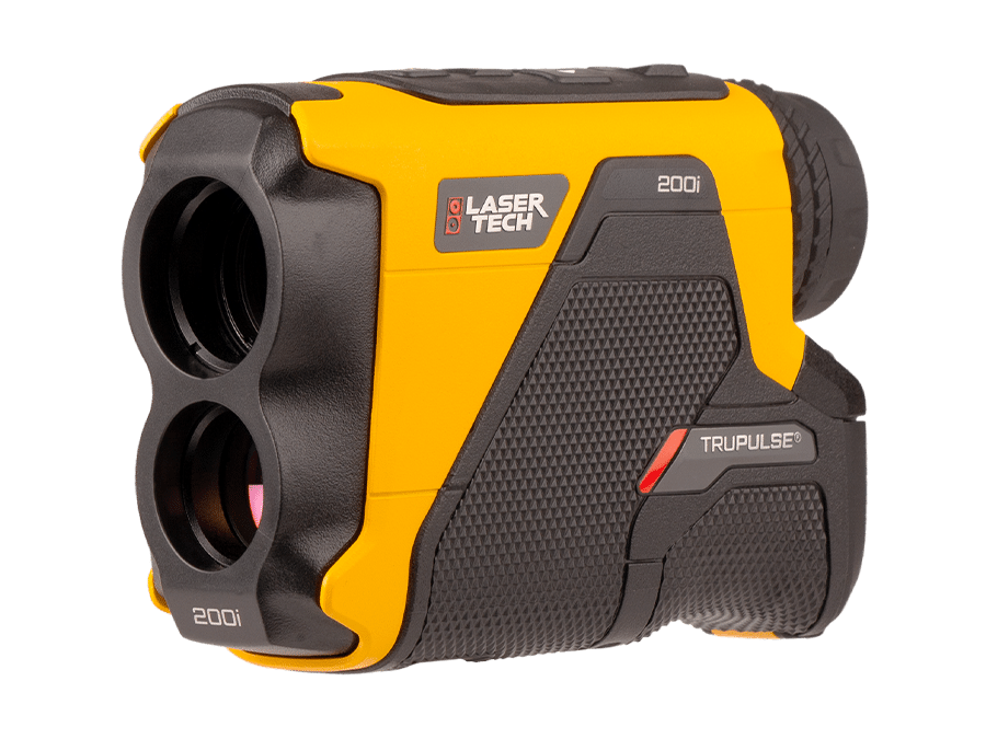
NEW: Capture Remote features using the TruPulse® series laser rangefinders.

Users can capture the location of multiple assets from one place for efficient data collection.

Users can overcome physically inaccessible, hazardous or poor GNSS environments using the TerraFlex software and LTI TruPulse lasers.

Downloads:


Leica Geosystems

Leica Zeno Mobile Laser Integration and Software Solutions

Leica Geosystems and Laser Tech team together to provide a field data collection solution. Professionals have been measuring offset points with earlier Leica Zeno software applications, and with the new release of the Leica Zeno Mobile app for Android™, you can continue to pair our TruPulse laser rangefinders for streamlined asset collection workflows.

  • Leica Zeno Mobile is a complete tool for data capture with the simplicity of an Android app. With an outstanding intuitive way of data collection, managing assets has never been so simple
  • New: Professionals can measure offset points quickly and simply using a single distance measurement, distance-distance or distance-bearing workflow
  • Access hard-to-reach and dangerous points (highways, rivers, dams) using offset measurements with the TruPulse laser rangefinder series
  • The first app in the market that can measure multiple features with only a single measurement. This saves time and assures topologic requirements are met

Downloads:

Bad Elf Flex® Laser Offset Workflows

Bad Elf offers trailblazing, survey-grade receivers that deliver flexible accuracy at highly affordable prices. Bad Elf’s Flex® receivers empower GIS and survey professionals to collect high-accuracy field data using any phone, tablet, or laptop.

Pair a Flex receiver with TruPulse laser rangefinders to perform laser offset workflows within Esri ArcGIS Field Maps, or use Bad Elf’s standalone app as an alternative. The Bad Elf Flex app seamlessly integrates the Bad Elf Flex receiver with TruPulse laser rangefinders for laser offset collection workflows that use a unique checklist-based approach to deliver flexible field choices to work crews of all skill levels.

Resources:

Other 3rd Party GIS Software/App Solutions

LTI’s TruPulse laser rangefinder is compatible and integrates with a number of 3rd party GIS software solutions, making your job quicker and easier. We have put together a few Quick Reference Guides to walk you through the integration steps.

Downloads:

Our LaserSoft® Apps for Laser Offsets

LaserSoft® Connect

With the free LaserSoft Connect App at their side, any user of ArcGIS® Field Maps app can measure laser offsets with a TruPulse® rangefinder. This exciting free app works with any brand of GPS/GNSS equipment, enabling users to acquire locations for those hard-to-reach features via point-and-shoot rangefinder workflows. Once you’re in Field Maps, just choose “Connect” as your offset provider, and you’ll be ready to tackle any mapping situation.

Downloads:

LaserSoft® MapSmart®

MapSmart is our flagship field data collection app, designed to help you fully utilize all the capabilities of our current products. This includes every Laser Offset method, with any GNSS receiver, and our Traverse workflow, which helps you maintain high accuracy positioning in RTK-denied environments. MapSmart is available on Android™ devices and Apple iPad. This simple yet powerful program easily integrates with Laser Tech devices and mapping accessories, creating a complete total station solution so you can quickly and accurately map, measure, or position anything.

Downloads:

LaserGIS Mapping Method 1 of 3

Distance-Azimuth Offset Mapping Method

The TruPulse 360i uses internal TruVector Compass Technology to add azimuth data to your rangefinder measurements.

The TruPulse 360i uses internal TruVector Compass Technology to add azimuth data to your rangefinder measurements.

Technical Setup: Your preferred GNSS receiver, a TruPulse 360i Rangefinder, and a mobile device running a TruPulse-integrated data collection program

Procedure: log your GPS location, use the 360i rangefinder to start mapping assets

Key advantage: one shot per asset

This video shows our LaserSoft Connect app bringing the Distance-Azimuth workflow into Esri’s ArcGIS Field maps. Though other available data collection programs may use a slightly different interface, the Distance-Azimuth workflow itself will remain the same.

LaserGIS Mapping Method 2 of 3

Distance-Distance Offset Mapping Method

The TruPulse 200i is a rugged and waterproof 2D rangefinder that boasts several performance enhancements vs previous models.

The TruPulse 200i is a solid option for accurate Distance-Distance offsets with minimal gear.

Technical Setup: Your preferred GNSS receiver, a TruPulse 360i, 200i, or 200X, and a mobile device running a TruPulse-integrated data collection program

Procedure: log position 1 and use the rangefinder to range your asset, move to position 2, log position 2 and use then range the asset a second time

Key advantage: can be performed with any TruPulse rangefinder without an encoder required

This video shows our LaserSoft Connect app bringing the Distance-Distance workflow into Esri’s ArcGIS Field maps. Though other available data collection programs may use a slightly different interface, the Distance-Distance workflow itself will remain the same.

TruPulse 200i laser rangefinder mounted onto a MapStar TruAngle II encoder.

Pair a TruPulse rangefinder with a MapStar TruAngle II to utilize the Distance-Angle offset workflow.

LaserGIS Mapping Method 3 of 3

Distance-Angle Offset Mapping Method

Technical Setup: Your preferred GNSS receiver, a TruPulse 360i, 200i, or 200X, a MapStar® TruAngle® II encoder, and a mobile device running a TruPulse-integrated data collection program

Procedure: Log position one, move to position 2, use the MapStar TruAngle II to establish your angle from position 1, use the rangefinder to map your asset(s)

Key advantage: most accurate method, immune to magnetic interferences

The Bluetooth® word mark and logos are registered trademarks owned by Bluetooth SIG, Inc. and any use of such marks by Laser Tech is under license. Other trademarks and trade names are those of their respective owners.

This video shows our LaserSoft Connect app bringing the Distance-Angle workflow into Esri’s ArcGIS Field maps. Though other available data collection programs may use a slightly different interface, the Distance-Angle workflow itself will remain the same.