Each current TruPulse® forestry hypsometer is waterproof and small enough to fit in your vest pocket. Built-in features and routines make accurate measurements quick and easy.
Smart Measurement Tools for Forestry Professionals
Our smart measurement tools include TruPulse® forestry hypsometers, LaserSoft® data collection apps, and the MapStar® TruAngle® II encoder. Overcome challenges that come with stem and sale boundary mapping, tree height measurements, slope grade monitoring, stockpile volume measurements, and more. Workflows use simple point-and-shoot actions to supply you with accurate and versatile measurement data while cutting down on field time and providing opportunities to improve your safety.
Smart Measurement Tools for Natural Resource Management
Our reflectorless measurement solutions help you easily monitor, assess, and manage resources such as sensitive plant species, wetlands, and streamside management zones. Use TruPulse laser hypsometers to perform LaserGIS® workflows that help you overcome signal issues caused by dense canopies. You can also map wildlife habitats, cliff dwellings, and monuments without occupying hazardous terrain or sensitive areas.
TruPulse 360i Forestry Hypsometer
Captures slope, inclination, distance, and azimuth measurements with each press of the fire button
Capable of performing all LaserGIS workflows, including our most streamlined Distance-Azimuth method
Includes a 3D Missing Line routine capable of measuring the horizontal distance, vertical distance, and slope distance values between any two points
Waterproof design invites use in all types of conditions
Includes wireless communication for use with data collection apps
TruPulse 200i and TruPulse 200x Forestry Hypsometers
TruPulse 360 users record wild ginseng plant locations without having to worry about GNSS signal strength.
Both capture slope, inclination, and distance measurements with each press of the fire button
Both pair with the MapStar TruAngle II encoder to perform the Distance-Angle LaserGIS workflow, our most accurate method for laser offset positioning (use a TruPulse 200x for the highest possible accuracy)
Both include a 2D Missing Line routine capable of measuring the horizontal distance, vertical distance, and slope distance values between two vertically aligned points
Waterproof designs invite use in all types of conditions
Both include wireless communication for use with data collection apps
TruPulse L2 Forestry Hypsometer
Captures slope, inclination, and distance measurements with each press of the fire button
Includes a 2D Missing Line routine capable of measuring the horizontal distance, vertical distance, and slope distance values between two vertically aligned points
Waterproof design invites use in all types of conditions
LaserSoft MapSmart App
Optimized to work with TruPulse hypsometers, MapSmart TruAngle II encoders, and any brand of GNSS receiver for offset asset positioning, even in RTK-denied locations
Built-in LaserGIS workflow options include step-by-step prompts and instructions to keep things easy
Creates export-ready map files that you can share right from your mobile device
LaserSoft Measure2 App
Keeps a digital record of your hypsometer measurements, complete with notes and photos
Creates export-ready measurement files that you can share right from your mobile device
Accurate tree height measurements are critical for reliable timber inventory evaluations. All of our forestry hypsometers include two on-board height measurement routines that don’t care how rough the terrain is. The 3-shot height routine comes in handy when a tree’s top is directly over its base. Missing Line routines provide the highest accuracy for tree heights in all scenarios. Each TruPulse hypsometer also includes a filter mode option that helps you measure through obstructing foliage.
TruPulse 360i Forestry Hypsometer
3-D Missing Line routine is ideal for measuring tree heights and linkage disequilibrium
Three-shot height routine is available when a tree’s top is directly over its base
Filter Mode targeting option helps you shoot past visual obstructions, like brush, and gather measurements to highly reflective targets only
Waterproof design invites use in all types of conditions
5X magnification scope with increased light transmission provides clear optics for easy and precise targeting
Includes wireless communication for use with data collection apps
TruPulse 200i and TruPulse 200x Forestry Hypsometers
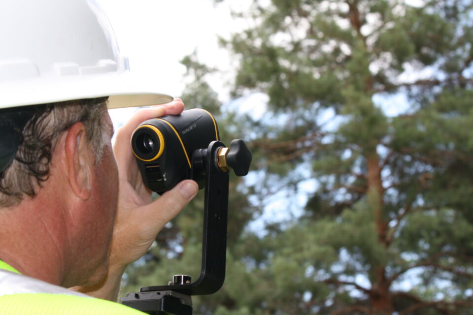
Forestry professional uses a TruPulse L2 hypsometer’s missing line routine to measure a tree’s height
2-D Missing Line routine is ideal for measuring tree heights
Three-shot height routine is available when a tree’s top is directly over its base
Filter Mode targeting option helps you shoot past visual obstructions, like brush, and gather measurements to highly reflective targets only
Waterproof design invites use in all types of conditions
TruPulse 200i: 5X magnification scope with increased light transmission provides clear optics for easy and precise targeting
TruPulse 200x: 7X magnification scope invites use over longer ranges
Both include wireless communication for use with data collection apps
TruPulse L2 Forestry Hypsometer
2-D Missing Line routine is ideal for measuring tree heights
Three-shot height routine is available when a tree’s top is directly over its base
Filter Mode targeting option helps you shoot past visual obstructions, like brush, and gather measurements to highly reflective targets only
Waterproof design invites use in all types of conditions
LaserSoft MapSmart App
Optimized to work with TruPulse hypsometers, MapSmart TruAngle II encoders, and any brand of GNSS receiver to create map files that can be shared right from your mobile device
Allows you to enhance mapped points with notes, photos, height values, and other hypsometer data
Offers a variety of LaserGIS asset positioning workflows, complete with step-by-step prompts
LaserSoft Measure2 App
Keeps a digital record of your hypsometer measurements, complete with notes and photos
Creates export-ready measurement files that you can share right from your mobile device
Smart Measurement Tools for Timber Harvest and Mill Operations
One main objective in a mill is managing stockpile inventories of wood chips or biomass piles. Inventory must be measured not only for accounting purposes but for production schedules. Utilizing our MapSmart App with the stockpile feature, users can generate volume and weight calculations without leaving the field or occupying unsafe positions on the actual pile. Easily determine the volume of any size stockpile, including those stored in bins or sheds.
TruPulse 360i Forestry Hypsometer
Captures distance, inclination, and azimuth measurements with each press of the fire button
Offers our most simplified workflow for stockpile volume measurements
Includes wireless communication for use with data collection apps
TruPulse 200i and TruPulse 200x Forestry Hypsometers
TruPulse i-Series lasers are rugged and waterproof handheld devices designed to simplify life in professional measurement.
Both capture distance and inclination measurements with each press of the fire button
Both can pair with a MapStar TruAngle II encoder to create a 3D data collection system
Pairing a TruPulse 200x with a MapStar TruAngle II creates our most accurate solution for stockpile volume measurements
Both include wireless communication for use with data collection apps
TruPulse L2 Forestry Hypsometer
Captures distance and inclination measurements with each press of the fire button
LaserSoft MapSmart App
Optimized to work with TruPulse hypsometers and the MapSmart TruAngle II encoder to calculate volume data without making you stand on the pile
Built-in stockpile volume workflow uses visual aids and simple prompts to keep things easy
Creates export-ready stockpile volume reports that you can share right from your mobile device
With TruPulse laser rangefinders and our LaserSoft MapSmart Android app, a field crew can quickly and accurately map, measure, or position practically anything. The solution is perfect for your professional or resource-grade jobs.
TruPulse 360i Forestry Hypsometer
Captures slope, inclination, distance, and azimuth measurements with each press of the fire button
Capable of performing all LaserGIS workflows, including our most streamlined Distance-Azimuth method
Includes a 3D Missing Line routine capable of measuring the horizontal distance, vertical distance, and slope distance values between any two points
Waterproof design invites use in all types of conditions
Includes wireless communication for use with data collection apps
TruPulse 200i and TruPulse 200x Forestry Hypsometers
TruPulse 200x laser hypsometers offer users the highest accuracy with each measurement.
Both capture slope, inclination, and distance measurements with each press of the fire button
Both pair with the MapStar TruAngle II encoder to perform the Distance-Angle LaserGIS workflow, our most accurate method for laser offset positioning (use a TruPulse 200x for the highest possible accuracy)
Both include a 2D Missing Line routine capable of measuring the horizontal distance, vertical distance, and slope distance values between two vertically aligned points
Waterproof designs invite use in all types of conditions
Both include wireless communication for use with data collection apps
TruPulse L2 Forestry Hypsometer
Includes a 2D Missing Line routine capable of measuring the horizontal distance, vertical distance, and slope distance values between two vertically aligned points
Waterproof design invites use in all types of conditions
LaserSoft MapSmart App
Optimized to work with TruPulse hypsometers, MapSmart TruAngle II encoders, and any brand of GNSS receiver to create map files ready for sharing right from your mobile device
Offers a variety of LaserGIS workflows for coordinate data capture without physically occupying asset locations or boundary lines that might otherwise require you to enter private property or stand on dangerous terrain
LaserSoft Measure2 App
Keeps a digital record of your hypsometer measurements, complete with notes and photos
Whether you’re modeling the trees or harvesting them, laying out engineering plans or managing the ecosystem, our laser rangefinders allow you to acquire more data to more types of targets – all from a single position.