Glen Whitford is a retired Project Manager (PM) for Saskatchewan’s Department of Highways and the current PM for Whitford Project Management. Decades of first-hand experience make Whitford’s familiarity with the challenges of mapping tasks seasoned and honest. Likewise, his opinions on field technology are truly valuable to Laser Tech’s (LTI) mission to provide quality products that help create a safer world. As of 2012, Whitford works with LTI’s TruPulse® 360°R laser rangefinder and LaserSoft® MapSmart® volume software to simplify his stockpile volume workflow.

Aggregates volume estimation is one function of Laser Tech’s MapSmart solution
LTI’s TruPulse® series is known for reliability in measuring distance, inclination, and angles. The 360°R is no exception, offering azimuth measurements and accuracy when operated at every possible angle. Whitford enjoys that TruPulse and MapSmart equipment help keep his post-retirement lifestyle sharp-minded and engaging. Still venturing out into the field offers Whitford a chance to evaluate the technology’s effectiveness.
“The MapSmart [app] is without question an excellent thing” he shares. Paired with his TruPulse 360°R, Whitford notes how much physically easier the technology makes his work. Aggregate measuring tasks now take much less time compared to “the standard way of surveying (still used today) where you have to spend a few hours climbing up and down huge gravel piles” explains Whitford.
Whitford makes note of how “taking shots and then spending several [more] hours calculating them for a total” is no longer an issue. He proclaims that LTI tech allows him to spend “only an hour at the most to shoot a fairly big pile (300-400 shots) and just seconds after the last shot [to receive] the total cubic metre results.”

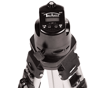
Laser Tech’s MapStar® TruAngle® interference-free angle encoder is MapSmart compatible
MapSmart works with any TruPulse that has Bluetooth communication and is compatible with our MapStar® TruAngle® encoder. Integrating the TruAngle into your mapping kit introduces interference-free compass technology that expands your abilities without sacrificing workflow efficiency. With or without the TruAngle added, MapSmart on Android™ makes it easy to collect reliable, professional field data, and calculate stockpile volumes all with the ease of using a smartphone app.
Spending less time acquiring measurements means that more jobs can be completed in shorter spans. Avoiding the physical demands that come with traditional surveying methods greatly reduces the risks of immediate or long-term injury. Whitford’s testimonial is further proof that LTI tech keeps employees safe and shortens project completion times.
Explore our devices, software, and solutions that make life easier for mapping professionals of all kinds.
Learn more about our mapping kits