June 6th, 2023: Steve Dagnall, Project Researcher working in the Gower Bone Caves, registers his TruPulse® rangefinder for its two-year warranty. We reach out to conduct a quick Q&A on how he uses the rangefinder for cave mapping across the Peninsula.
The Gower Bone Caves of South Wales are well known within the archaeological and palaeontological community. A quick bit of research or a visit to their website makes this obvious:
“Caves of the Gower peninsula in South Wales have provided a rich source of archaeological and palaeontological discoveries. These have been of significant scientific importance, especially to the early understanding of human origins. As many of these finds included bones of fauna and humans, these sites have been referred to as bone caves.”
Dagnall is the webmaster of the Gower Bone Caves website. He is also part of an ongoing, collaborative long-term project that involves mapping caves and their entrances. In this Q&A, Degnall explains how he uses a TruPulse rangefinder for cave mapping tasks.
Steve Dagnall, Project Researcher working in the Gower Bone Caves, uses a TruPulse rangefinder for various cave mapping tasks.
From searching the Internet for a better solution for taking distance/bearing offset measurements than my setup at the time was capable of.
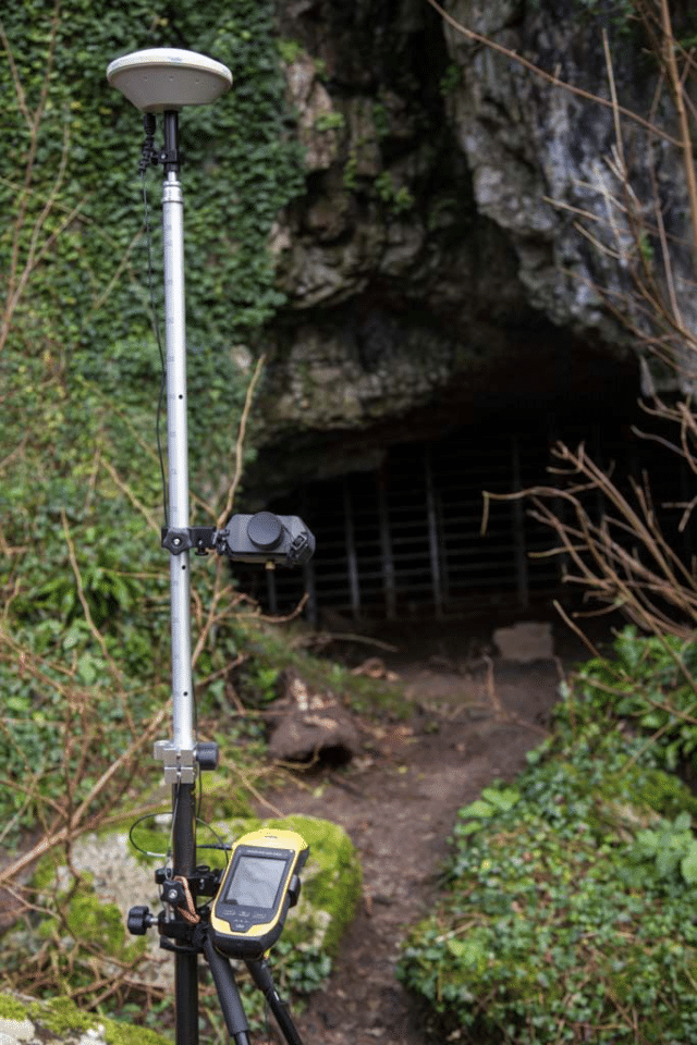
The rangefinder is used to record locations of archaeological cave entrances. This task is part of a long-term personal project I’m working on with others. We’re covering an area of the UK known as the Gower Peninsula. The project also involves curating images, keeping a bibliography, and collating a digital library of appropriate documents. Many of these caves have not been accurately mapped before. Over here (in the UK), decimeter accuracy is considered good practice by the Ordnance Survey. So, that’s what I aim for.
Mapping the heights of different cave entrances is a particularly important metric. This can often become quite difficult to achieve. As these caves are mainly located close to cliff faces, and occasionally within narrow ravines, safety is a concern. There is also a high potential for bouncing signals and rarely any phone reception.
I can usually measure up to decimeter accuracy at the cave entrance just by following the Trimble guidelines for getting good, quality data. I’ll also post-process the measurements with correction data downloaded from the Ordnance Survey as a finishing touch. On the other hand, RTK (Real Time Kinematic, a technique used to increase the accuracy of GNSS signals that uses a fixed base station’s corrections) can be difficult. While it’s not impossible, the lack of a reliable phone connection can make the process tough. Whilst satellite correction data is an option, it doesn’t take long to become prohibitively expensive. This is where my TruPulse rangefinder comes into play.
In the past, I had tried using the distance/distance offset method to overcome challenges that come with error-tied bearing points. I found that the terrain in these caves did not allow for good enough geometry for this method to work. Then, I started using a rangefinder to complete distance/bearing offset routines and found success. This is now an essential part of completing the fieldwork for cave features that are difficult to safely access. I’ll also use the distance/bearing method whenever it’s impossible to record GNSS data at a feature’s location.
As described in the previous question, the ability to record high-accuracy distance/bearing offsets within the challenging terrain of archaeological caves. I’m also fond of how easy it is to recalibrate the instrument and the prompts I receive whenever this needs to be repeated.

The Gower Bone Caves of South Wales are well known within the archaeological and palaeontological community.
Yes. I used a competing brand’s rangefinder, Trimble Geo 6000 XH with a range pole, a bipod, and an external antenna.
Pretty recently, in February of 2023.
Yes they have! Target acquisition is a much more precise and positive process than it was with my previous rangefinder. Now I know pretty quickly if I have made a mistake. When necessary, repeating the measurement is not such a painful process. This is especially true as the pole mount is far more stable than before. The best part is the ease with which the instrument can be calibrated.
Yes. For sure. It is an easy unit to both calibrate and use and I am delighted with it.
Do you have an interesting story about LTI products? Share with our team any story, big or small, about how you use Laser Tech products to be featured on our website and social media.
Share Your Story