× Close
Quick Links:
Main Navigation:

LTI News

Share

TruPulse Mapping Accuracies

By S Colburn, 04/20/21

A long-standing mapping customer of ours, who owns all our various TruPulse® models, asked if we could summarize the expected accuracies of each model for positioning objects in the field. They suspected that some of the models and some of the methods they used may not meet the needs of certain projects.

They did not want to risk collecting data outside of the proposed error tolerance they had to work with.

Range-Range TruPulse Mapping Method measures distance and tilt to the target from two known points


TruPulse Accuracies via Models and Mapping Methods

We decided to build a table listing each model and the corresponding mapping methods that applied to them, so they could easily see the possible error contribution of the laser and method they were using.

  • TruPulse 200, 200B, 200X: measures Distance and Tilt
  • TruPulse 360, 360B, 360R: measures Distance, Tilt and Azimuth
  • TruPulse with TruAngle: measures Distance, Tilt and Angle

Assessing TruPulse Accuracies

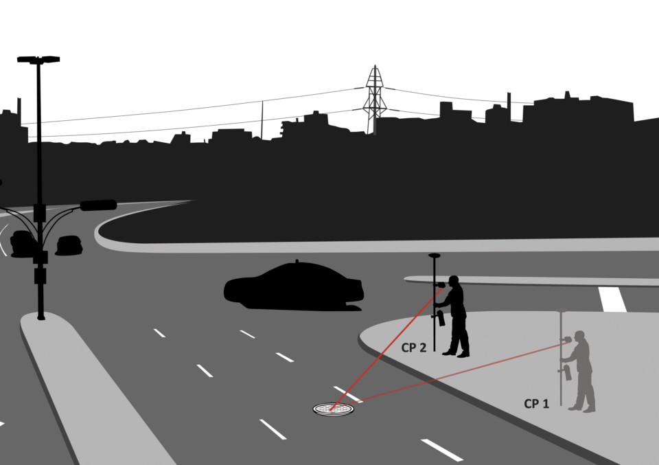
Range-Angle TruPulse Mapping Method measures distance, tilt, and angle to the target

To do this, we first determined the expected or “typical” accuracy of the laser rangefinder when measuring to ordinary objects at normal distances. As expected, we found this to be better than our published accuracy, which we like to be conservative with to cover the weaker, less common targets. We used the published specs for the Tilt, Azimuth and Angle sensors as they represent typical accuracies already.

Next, we did the math to come up with accuracy estimates for the three most used mapping methods. We used two reference distances, one at 50 meters and the other at 100. Our customer said most of the time they did not shoot past 50 meters and we told them that for some of the methods, they would achieve even better results at closer ranges. When it makes sense, they occasionally need to measure 100 meters to position objects so they wanted to know what that ceiling was.

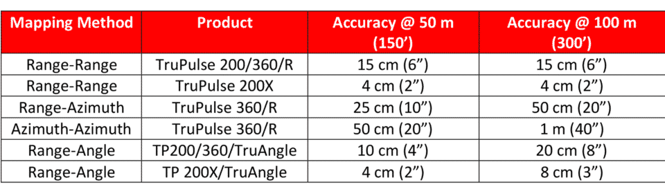
Range-Azimuth TruPulse Mapping Method measures distance, tilt, and azimuth to the target

A Summary of TruPulse Accuracy Data

Summarizing all the data into the table below, we see how each laser model performs in each of the mapping methods described. Note that the TruPulse 200X performs the best, both on its own in the Range – Range method and paired with the TruAngle product in the Range –Angle. Another interesting fact is that the possible errors in the Range-Range method do not increase with distance to the target.

Since the accuracy of the distance measurement from our lasers do not vary over this range, the positioning accuracy they can attain does not either. The uncertainty of the other methods does increase with distance due to the operator measuring a horizontal azimuth or angle.

Think of the angular error as how much of a wall a flashlight will illuminate when you shine it from 5 feet away vs. 10 feet. It is a small amount at the closer distance and a larger amount the further you move away.

Chart showing TruPulse mapping accuracies by mapping method


The customer almost always maps with GPS and just like our laser models, they have them of different accuracy levels, from sub-meter to survey grade. They were very thankful to have this handy chart, that they could easily add their GPS accuracy values to. This way they could look at their total error budget for the project and choose the perfect combination of GPS and Laser mapping to get the job done.


Want to learn more?

Contact us today for more information on our TruPulse series laser rangefinders, or to schedule a practical demonstration.

Contact Us