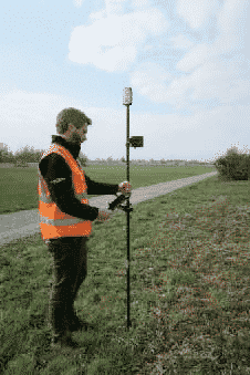
GIS professionals and field crews rely on the use of Global Positioning Satellites (GPS) and Global Navigation Satellite System (GNSS) antennas, designed to receive specific signals for accurate feature and asset location data.
However, satellite signals can be easily compromised by man-made features and Earth’s natural assets.
“Assets in places such as a busy roadway or under dense tree canopy can make it difficult for users to capture location information accurately, safely, and efficiently.” said Derrick Reish, Senior Product Manager at Laser Tech (LTI). The TruPulse® laser rangefinder series enables users to accurately measure assets without having to physically occupy the location. Using this offset workflow, crews can work quickly, accurately, and efficiently.
The November 2020 release of Leica Zeno Mobile introduces new compatible sensors and workflows with DISTOs and TruPulse laser rangefinders. The Leica Geosystems and Laser Tech integration creates a new guided workflow. This invites users to integrate a TruPulse laser rangefinder into their workflow and achieve centimeter accuracy in GNSS impaired environments.
The goal is improving one’s efficiency and safety in the field. This integration also supports Leica Zeno FLX100 Smart Antenna, a compact, simple to use, and flexible antenna for everyone. See below for workflow routines.
TruPulse Rangefinder Integrated Laser GIS Mapping Solution
An offset is the combination of a distance and a direction. Combining a recorded GPS position with the associated distance and direction to your object ensures high-accuracy positioning data. In the setting of GNSS, an offset is used to define a shift from one location to another. Data measured with the laser is in three dimensions to incorporate any differences in elevation.
LaserGIS®, which is defined as applying offsets to features by recording both a GNSS position, associated distance, elevation, and direction to the object of interest is very useful in challenging situations.
Need to record the attributes of a power pole that is on the other side of a steep, narrow ravine? Avoid risking injury by using the offset capability to stand at one side of the ravine and simply record the offset to the pole on the other side. In fact, the offset function allows the user to stay at one location and record the offsets and attributes of all features within sight before moving to the next location to do the same. Don’t even consider climbing across the ravine!
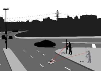
Distance-Distance Laser GIS Mapping Method
LaserGIS offers options for collecting high-accuracy measurements. Distance-Distance requires two measurements to log each point, using the geometry of a triangle to calculate each coordinate. This method requires only a laser rangefinder, making this laser mapping offset the most cost-effective. Distance-distance is great for collecting geo-location-based information and mapping electric utilities.
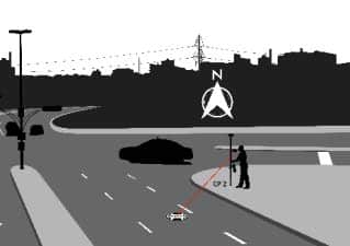
Distance-Azimuth Laser GIS Mapping Method
Horizontal Distance-Azimuth is another measurement method where the user pivots around their origin point while shooting to any feature in view. Most used in urban forest mapping, wetland delineation, street furniture mapping, and sign and signal inventory, the only downfall to this routine would be any magnetic objects near your site that may compromise the accuracy of your measurements.
The final laser mapping offset technique is Azimuth-Azimuth. This method can be used with the TruPulse 360° models and is useful if you are unable to get a successful reflection when using the horizontal distance method:
Integrating the Leica Zeno FLX100 smart antenna (a multifrequency survey grade device) can take GNSS measurements of up to 2cm, when using HxGN SmartNet RTK technology. Similarly, using the FLX100 and SmartNet with TruPulse laser rangefinders, makes very accurate offset point measurements possible.
If for any reason the user is unable to get a mobile internet connection for RTK to work, Zeno Mobile is able to post process all GNSS measurements in the cloud using the Smart Positioning feature. This means that all the offset points measured with the TruPulse will have their location accuracy improved.
LaserGIS, can be used for just about any application from mining, GIS, narrow ravines, mapping features on private properties, but most importantly, crews no longer need to occupy high-risk areas to collect a measurement.
Leica Zeno Mobile – What’s new – November 2020 release
Leica Zeno FLX100 Smart Antenna
Contact us today for more information on our professional measurement devices and applications, or to schedule a practical demonstration.
Contact Us