Along with the typical day-to-day tasks that today’s forester tackles comes the responsibility of designating Streamside Management Areas (SMAs) or Streamside Management Zones (SMZs). These buffers help keep moving water and surrounding areas protected from human activity.
Respecting these minimum distances helps prevent excessive erosion, unnatural sun exposure, and other potentially destructive changes to the habitat. When foresters mark these protected zones, Laser Tech’s TruPulse® i-series laser rangefinders, the TruPulse 200i and TruPulse 360i, can be especially useful tools.

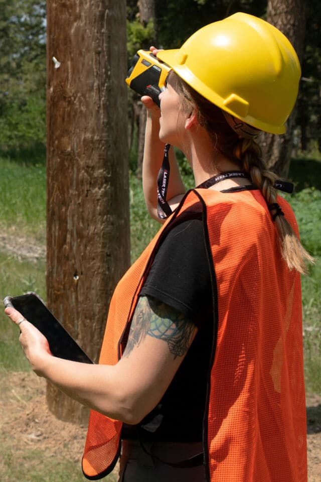
TruPulse 200i and TruPulse 360i forestry rangefinders are rugged and waterproof handheld devices designed to simplify life in professional measurement.
These next-generation professional measurement devices boast a rugged IP67 water/dust proof rated design. Their newly refined targeting capabilities make it easy to quickly capture accurate height, distance, and angle measurements. The TruPulse 360i’s built-in compass expands user capabilities with azimuth data. Both i-series rangefinders can achieve up to 0.1-meter distance accuracy within a 1,000-meter range. Measurement data is readily available for instant relay to smart devices via Bluetooth connection, doing away with any need to carry pen and paper.
Two individuals work together to mark an SMA buffer zone. One, we’ll call them the Lead Forester, is equipped with a TruPulse rangefinder and a working knowledge of how to gauge high-water marks. The other, the Forester’s Assistant, carries tree marking materials like spray paint or flagging tape. This can be an intern or someone new to the forestry realm in general.

Both team members carry two-way handheld radios. The Lead Forester works streamside. Splashes of water or even dropping their forestry rangefinder into the stream is not a worry thanks to the rugged and waterproof design. The assistant heads out into the brush, staying within a distance that is about as far out as the state regulations for SMAs call for. The Lead Forester uses their TruPulse laser to direct the assistant into this range. Ideally, and most likely, the assistant remains in sight of the Lead Forester.
With the rangefinder attached to a survey pole or tripod, the Lead Forester uses the first high-water mark as a point of origin. From there, they use the rangefinder’s 5x optical zoom to shoot out into the brush. It doesn’t take long to capture a distance measurement to a winning tree. This tree’s distance from the high-water mark is close to, but not less than, the SMA’s minimum required distance. Using the radio, they direct their assistant toward this winning tree and have it marked. The pair works their way down the stream repeating this process with full confidence in their measurements and markings.
If the personnel are available, a 4-person team could split into groups of two. Each group would have their own TruPulse rangefinder. Working both sides of the stream at the same time may present the most time-efficient workflow. If tasked with marking SMAs on your own, you could stay out in the brush and choose trees to stand next to while aiming the forestry rangefinder to the adjacent high-water line, marking winning trees along the way.
It is easy to keep a record of each tree’s geospatial location and distance from the bank. There is no need to write anything down by hand. The lead forester utilizes the rangefinder’s Bluetooth capabilities to relay measurement data to their preferred data collection app on a tablet or smart device. If using a TruPulse 360i, they can even keep track of the distance between each marked tree.
TruPulse i-Series user sends rangefinder data to their smart device via Bluetooth connection.
The catalog of TruPulse-compatible data collection solutions is large and ever-growing. Some key examples include Esri ArcGIS Survey123 and ArcGIS Field Maps, along with Laser Tech’s own LaserSoft® MapSmart® app. In any case, a user will have the ability to build digital forms for each new project. Once out on the job, just tap on a customized field value, an example could be “Distance from Bank”, use the forestry rangefinder to obtain a measurement, watch the app auto-populate with rangefinder data, and repeat. These modernized workflows boost efficiency and consistency in all sorts of data collection and mapping projects.
Along with a TruPulse laser’s simplified point-and-shoot capabilities for horizontal, vertical, and slope distance values come built-in routines for measuring heights and point-to-point missing lines. Neither routine requires the user to occupy any object locations; in each case, targets only need to be within a clear line of sight.
The three-shot routine only requires users to capture one distance measurement to the target object itself. After this, the inclinometer sensor comes into play as angle measurements complete the workflow. This is particularly helpful when brush or other visual obstructions partially block a target object’s base or top. Just aim to the base, then the top, and disregard any obstructions.
Three-shot Height Routine Workflow:
Result: Height of the target object
With a TruPulse 360i, foresters can utilize the missing line routine to capture the distances between marked trees with two quick shots. This can help achieve consistent spacing and make sure that all distances between markers fall into regulation. The same feature can also determine slope grades, which is helpful since some states require adjusted minimum distances based on the steepness of surrounding terrain.

A TruPulse rangefinder and compatible GNSS receiver user heads out into the field to remotely position geospatial assets.
Two-Shot Missing Line Routine Workflow:
Results: Horizontal, vertical, and slope distance values between Points A and B
Too many assets make it difficult to capture coordinates via traditional methods, which require users to physically occupy the asset’s location with a GNSS receiver and survey pole in hand. In situations like these, your safety and efficiency can get a boost thanks to LaserGIS® workflows. By adding TruPulse rangefinders into the mix, you can pick safe and convenient locations to remotely position assets from. With a TruPulse 360i in your toolkit, this process can be as simple as standing at a choice location and firing the laser at your target object(s). Your GNSS receiver and forestry rangefinder will work together to do the rest.
Range-Azimuth Offset Mapping Method Workflow:
For more information about Laser Tech and our products, head to lasertech.com/laser-distance-measurement. Dive into LaserGIS workflows, training, and compatible solutions by visiting lasertech.com/gis-laser-offsets. Check out our collection of product information and training videos that help get you ready for new levels of efficiency in the field at youtube.com/@LaserTechPro.
originally published at TimberLineMag.com on September 4, 2024
Don't want to miss out on future updates? Subscribe to our blog for the latest news, trends, and expert insights from LTI. Head on over to our subscription page to sign up today!
Sign me up!