Laser Tech’s (LTI) Application Training Specialist offers a streamlined overview of basic MapSmart volume training. The quick, easy, and accurate workflow uses two examples for volume assessment via our LaserSoft MapSmart data collection app and TruPulse laser rangefinders.

• Pulse laser using time of flight
• Measures directly to any type of surface
• Will discriminate a prism target
• Measures vertical angle from the horizon
• Used to calculate Horizontal Distance for XY positioning
• Used to calculate Vertical Distance for Elevation (Z)
• Compass bearing from Magnetic North
• Direction and HD are used to locate a point
• Effected by local distortion to Earth’s magnetic field
•Measures horizontal angle from a known reference
• Direction and HD are used to locate a point
• Not influenced by Earth’s magnetic field
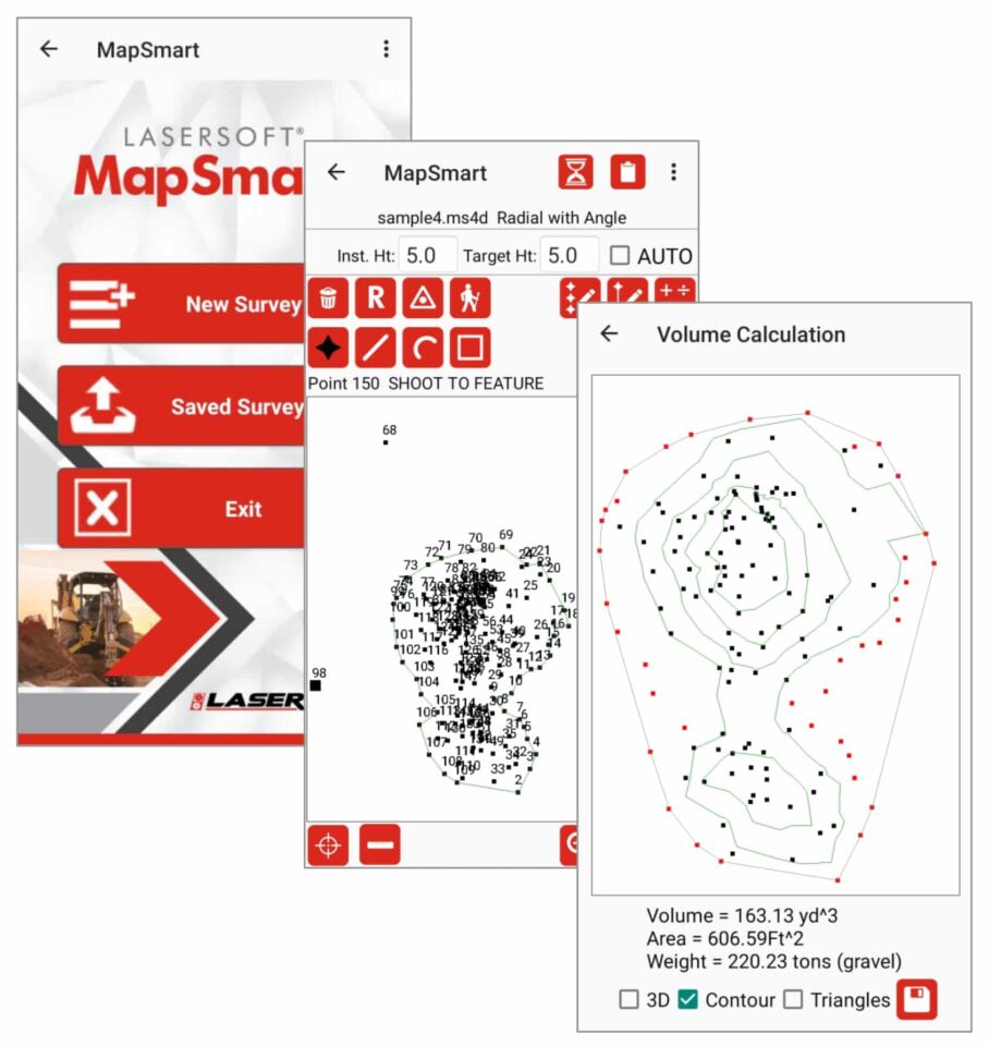
•Fully functional data collection tool
• Onboard Volume routine
• Measure in minutes
• Immediate results
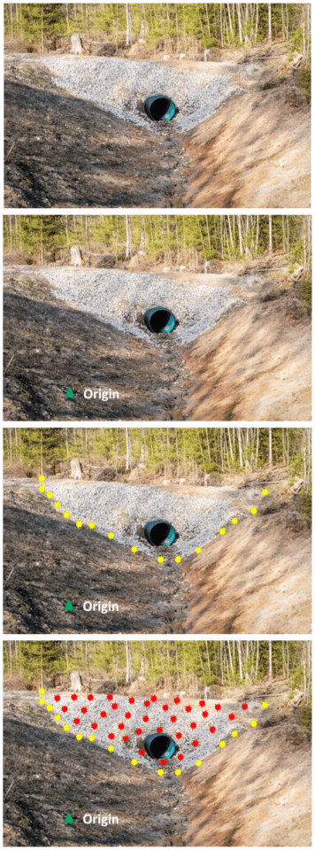
These images help provide a visual reference for MapSmart volume training via culvert restoration.
• Select a suitable place for the starting instrument position, or Origin, where you can see most of the culvert fill
• Make sure you can shoot to a second point that may be necessary to see all of the fill
• Set the Origin or starting Control Point
• Put a temporary mark in the ground at the Origin and set the laser system up over it
• Start a New File and select either a ‘Volume with Azimuth’ or ‘with Angle’ survey
• Enter an accurate height for the laser Instrument above the mark on the ground
• The target height will typically be 0.0 when shooting directly to the surface
• Accept the default values of 0,0,0 for the Origin and reference the angle, if used
• With the Base shot icon highlighted, shoot in the points (yellow)
• Follow the line of separation between the fill and the existing ground
• Shoot in more points where the line changes direction often, fewer where it is straight
• Make sure to measure points at all major breaks in slope and direction
• Tap the Pile icon and shoot in points on the material (red)
• Make sure to get good coverage and take points at all the breaks in the slope
• If another instrument position is required, tap the Create New CP button
• Move the system to the other side and use the same workflow to map in the base and pile points
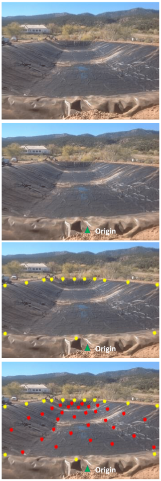
These images help provide a visual reference for MapSmart volume training via pit volume measurements.
• Select a suitable place for the starting instrument position, or Origin, where you can see most of the pit
• Make sure you can shoot to a second point that may be necessary to see all of the pit
• Set the Origin or starting Control Point
• Put a temporary mark in the ground at the Origin and set the laser system up over it
• Start a New File and select a ‘Volume with Azimuth’ or ‘with Angle’ survey
• Enter an accurate height for the laser Instrument above the mark on the ground
• The target height will typically be 0.0 when shooting directly to the surface
• Accept the default values of 0,0,0 for the Origin and reference the angle, if used
• With the Base shot icon highlighted, shoot in the points (yellow)
• Follow the topmost edge of the pit before the slope breaks down
• Shoot in more points where the line changes direction often, fewer where it is straight
• Make sure to measure points at all major breaks in slope and direction
• Tap the Pile icon and shoot to points down in the pit (red)
• Make sure to get good coverage and take points at all the breaks in the slope
• If another instrument position is required, tap the Create New CP button
• Move the system to the other side and use the same workflow to map in the base and pile points
• When complete, tap the Calculate button and choose Volume
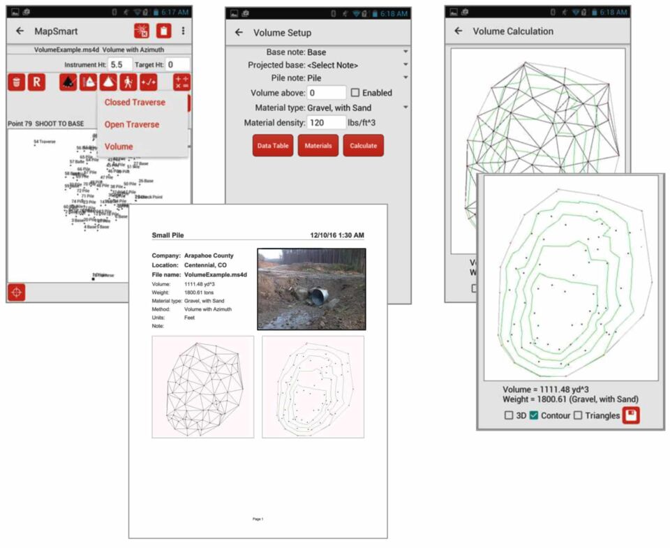
The final step in MapSmart volume training is to analyze the results.
• Select a Material type if the tonnage is desired and tap the Calculate button to view the fill or pit volume result
• Uncheck the Triangles box to view the Contour map only
• Make sure the shape looks correct and that nothing is out of place. This gives you confidence in the result.
• Tap the Save button to generate a PDF report
Our experts are ready to personally guide you through using our tech to perform these workflows.
Request a Demo