Three companies have partnered together to keep up with market demands for hard-to-reach, high-accuracy mapping. Each agreed on emphasizing safer workspaces and quicker solutions as top priorities.
Laser Technology, Inc., (LTI), Eos Positioning Systems® and Esri®™ collaborated on the development and creation of the world’s first laser offset mapping solution. Together, they have produced the ArcGIS Collector workflow!
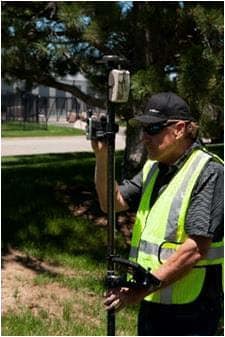
For years, field crews have faced challenges in achieving high-accuracy 3D mapping at hard-to-reach locations. Too often do field crews find themselves in physically dangerous positions. On top of this, they are stuck with inefficient workflows that require extensive training, tools, and programs. This makes far too many tasks tedious and time-consuming.
World’s first laser offset solution integrates TruPulse Rangefinders
The integration of the Esri ArcGIS® Collector®, Eos Arrow Series™ GPS/GNSS receiver, and LTI’s Laser Rangefinder solutions allows field crews to operate in GNSS-impaired environments at centimeter-accurate levels without sacrificing accuracy. Gone is the need to leave the collector/AGOL environment. Thus, a highly efficient workflow in a low-risk area is established.
This combination of technology amounts to a total station-like workflow, completely within the Collector environment (when using laser rangefinders and RTK GNSS.)
The solution provides numerous offset-mapping methods. Field crews can now seamlessly capture, measure, and share their centimeter-accurate asset data into ArcGIS online in real-time. Additionally, an ability to integrate any laser option for preferred accuracy offers freedom of choice.
The benefits of this solution are numerous. This is especially relevant in areas where GNSS does not work and locations that are dangerous to occupy. Roadways, trenches, forests, and urban canopies now have a superior mapping solution. Not only does accuracy and efficiency increase, but safety liabilities wither away. The best solution for you and your crew is finally available.
Find Out More on the World’s First Laser Offset Solution.
Esri, the global market leader in geographic information system (GIS) software, offers the most powerful mapping and spatial analytics technology available.
Eos designs and manufactures the world’s premier, high-accuracy GPS / GNSS receivers for the Bring Your Own Device (BYOD) market. The Arrow Series™ receivers feed submeter, subfoot, and centimeter RTK GPS / GNSS location data into any iOS, Android, and Windows device.
Contact us today for more information on LTI's offset mapping devices and software, or to schedule a practical demonstration.
Contact Us