Technology has transformed our way of communicating and performing our work-based tasks that help us maximize our output, complete jobs quicker, and most importantly, increase our safety in the field.
The New World of Tech is gaining momentum, and while we haven’t conquered it by any means, the past decades have provided us with substantial milestones that are helping us pave the way to an even more connected future. GNSS, the Global Navigation Satellite System, is helping us shape this future.
Satellites are steadily multiplying and building a technological atmosphere providing humans with faster connection speeds and modernizing the Earth into an autonomous civilization. GNSS is becoming the world’s GPS: providing us with coordinates for whatever we may need. Whether we are looking to construct new buildings, provide more telecommunications for our 5G future, or to simply find where we are going when we get lost, GNSS provides autonomous geo-spatial positioning with global coverage to help us discover, build, and implement.

Users who integrate GNSS receivers into their workflow have their position triangulated by grabbing signals from at least four GNSS satellite signals. Multiple satellite navigation systems increase a user’s accuracy as well. Discovering, building, and implementing, however, can be tricky when you happen to arrive in a GNSS impaired environment.
A GNSS impaired environment happens due to the obstruction of the signal from buildings, terrains, or anything that causes the signal to be blocked. In addition, a GNSS satellite signal can be compared to a 50-watt lightbulb, making it an already weak signal to begin with.
The need for real-time, high-accuracy GNSS positioning is growing. Regulatory requirements on spatial data accuracy is increasing. Collecting highly accurate horizontal and vertical data is achievable in some areas, but how do we reach centimeter accuracy in GNSS impaired environments?
LaserGIS is our term for using TruPulse laser rangefinders as an integrated tool within workflows that allow users to assign coordinate and characteristic data to assets without physically occupying their location(s).
You can achieve centimeter accuracy in GNSS impaired environments on assets located in alleyways, under trees, and even in the middle of a busy street by uniting hardware and software solutions from industry leaders:
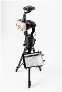
GNSS mapping solution integrated with Laser Tech’s TruPulse 200X
Esri®: the leaders in GIS software for the field and office.
Eos®: the leaders in high-accuracy GNSS receives for BYOD.
Laser Technology, Inc®: The leaders in high-accuracy laser rangefinders and encoders.
To learn more about this solution and achieving centimeter accuracy in GNSS impaired environments, you can review the course recording presented by GIS Mapping experts by viewing their GNSS Mapping Webinar presentation.
Contact us today for more information about LTI's GNSS mapping products and solutions, or to schedule a practical demonstration.
Contact Us